
|
Quote of the day! Our value is not determined by who we are, what we do, or what we look like, but by the Price that was paid for us. Romans 5: 8 |
|
Search Branson , Lake Taneycomo & Table Rock Lake areas. Homes, Condos, Resorts, & Commercial |
|
Sue Andersen |
|
Branson, Mo Flood 2008 Table Rock and Taneycomo Flooding Presented by Sue Andersen Realty |

|
Enjoy the “Beauty of the Ozarks” with Real Estate at Branson Mo and the Tri Lakes Area |
|
Branson is Alive and Well! April 2008
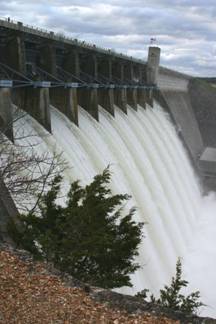
We want to stress that the photos and events described in this site are quite some distance from most of the attractions and businesses in Branson. The theatres, theme parks, and other entertainment venues have been unaffected by the flooding and high water, and are open and running their regular, uninterrupted schedules. The Branson Landing is in full swing. Even the resorts and businesses along the lakes are open and eagerly accommodating their guests. If in doubt about an activity, call ahead, but do not hesitate to come visit us. You might even get to witness and show your kids the rare and awesome site of water cascading over the spillways at Table Rock Dam!
Background -White River Lakes The wild White River Basin, stretching from the Oklahoma/Arkansas border northward to I-44 at Springfield, MO, and back southward to Memphis, TN,. has been somewhat tamed by a series of dams creating four lakes. Beaver Lake is the first of the chain. From there the water is released into Table Rock Lake. Table Rock Lake releases into Lake Taneycomo, which in turn releases into Bull Shoals. Bull Shoals releases into the White River. Lake Norfolk is an independent lake that also releases into the White River approximately 45 miles downstream from Bull Shoals Dam.
This system of lakes was completed in the late 1950’s and 1960’s for the purpose of flood control with the added benefit of generating hydroelectric power. The system put aside the “Old time legends of flash floods containing 50 foot walls of water coming out of the Ozarks hills and mountains, destroying everything in their path along the White River”. The ingenuity and engineering was an unbelievable and unprecedented accomplishment.
Four of these lakes, Beaver, Table Rock, Bull Shoals and Norfolk are owned by the US Government and controlled by the Army Corp of Engineers. No Private or Commercial building is permitted in the flood plain, below the Government Take Line. Lake Taneycomo, when it was built, was not under the Corp of Engineers control. Building was permitted in the “Flood Plain”.
Leading up to the Flood! In February and March of 2008, mother nature challenged the system. Record rainfalls were recorded for both February and March.. Up through the second week of March these unsurpassed rainfalls had little impact on the lake system. The lakes were doing their job. But unfortunately, we were issued a new challenge. A tremendous buildup from the Gulf of Mexico was about to collide with a buildup from the southern Pacific. These two were to meet over the Ozarks. This meeting would generate a tremendous amount of rain over the entire water shed of the five lakes. Branson got by easy with only 5.5 inches, whereas locations to the north reported 8 inches or more within 24 hours. The lake system met the challenge. Tributary rivers into the White River crested at record high flooding, but the White River Lakes area was not effected. The lakes system held the majority of the water back without emergency releases. This helped the residents of the lower White River, those beyond the lake system control, by preventing an increase in the flooding that they were experiencing due to run off originating below the White River lakes system.
As a result of this storm system, the Table Rock Lake water level increased 11 feet in 3 days. It leveled off at 928’ above sea level, within 3 feet of maximum flood pool.
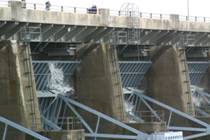
Within a few days after the heavy storm, Table Rock increased releasing water to 24 hours a day through the hydroelectric turbines, 14,000+ cubic feet per second. The local area continued to receive light to moderate showers every few days. The 24 hour a day release had a very marginal effect after 10 days. We were now at approximately 926. The Army Corp of Engineers then announced that 5 flood gates would be opened at Table Rock Lake on top of the hydroelectric turbines, totaling 20,000 cubic feet per second, to relieve the water. Beaver Lake, above Table Rock, had reached it’s maximum flood pool and had opened its flood gates to relieve it’s water. This is the first time in Beaver Lake’s history that the flood gates had been opened. Table Rock no longer had Beaver Lake to help protect the system, as it was full.
The Flood! The first of April brought another challenge by mother nature. Once again a massive push from the Gulf was going to collide over the Ozarks with a storm from the Pacific . The combined storms would again cover the entire White River Basin.
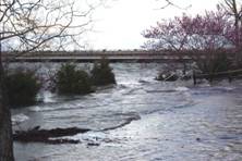
Unfortunately, the forecast was correct. The entire White River Basin received another massive rain. Branson received 4.5 inches in 30 hours. Since Beaver Lake was already full, it had to release the new rainfall watershed into Table Rock. Table Rock Lake opened all 10 gates to an unprecedented level, 46,500 cubic feet per second. Even with the gates at an unprecedented level, open 2.5 feet, Table Rock continued to rise and crested at 933.25 feet, which is above the flood pool, the highest level in its history. The increased release of water from Table Rock has flooded many homes and has been disastrous to many families living along Lake Taneycomo .
Bull Shoals was now at flood stage but was still holding the majority of the water back.. Norfolk Lake was at a record high flood level and had to open all of its gates to the White River. This is the first time since the construction of the lake system that all lakes have reached their maximum capacity at the same time. Once again, the lower White River, central Arkansas, was severely flooded.
Update 4/16/2008 The four lakes are now below maximum flood pool by a foot or more and all flood gates have been closed. Water level on Lake Taneycomo is back to normal. Residences on Lake Taneycomo are starting to evaluate the damage. The Army Corp of Engineers and residences are closely watching the forecast weather as we are just beginning the rainy season for our area.
Added Thoughts! We have seen a lot of flooding and high water on Lake Taneycomo due to the all time record amount of rainfall in February and March. Keep in mind that this does not even come close to the water levels from the flood’s in pre 1957, before construction of the dam, when all of downtown Hollister was flooded (4 foot of water in the English Inn - 1945), consistent flooding to downtown Branson up to the railroad tracks and the original Branson Taneycomo bridge was destroyed (1927). The documented pictures of pre-dam floods (before 1958) keep the legends of the wild White River flash floods alive.
Another interesting facts is that, although the 46,500 cfs release from Table Rock dam this month was quite remarkable, it is a mere fraction of the approximately 500,000 cfs release capacity of the main 10 flood gates. If you add the capability of the emergency spillway, the U.S. Army Corp of Engineers has the ability to release approximately one million cfs from Table Rock dam.
I would like to extend a special thanks to the Corp of Engineers, Stone and Taney County Sheriff’s Departments, Branson PD and a host of volunteer emergency workers who have done their very best to protect our properties and our safety throughout the “Civil Emergency”. Once again, The Ozarks has proven to be a place where neighbors reach out to help neighbors when times get tough.
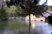
Please enjoy these pictures and remember our neighbors in your prayers!
Sue Andersen Realty |
|
Observations by a 30 year Local! As Accurate as my Memory Allows?? April 2008 |
|
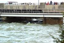
Look closely and you will see the water coming over the top of the flood gates! |
|
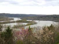
Photos from April 2008 and 1957 |
|
Photos from Forsyth, Mo |
|
Reference levels: Table Rock top of flood pool - 931.00 Beaver top of flood pool - 1130.00 Bull Shoals top of flood pool - 695.00 Norfolk top of flood pool - 580.00 |
|
BRANSON IS ALIVE AND WELL OPEN FOR BUSINESS AND FUN AS EVER |
|
Pictures and Website |
|
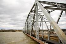
Pictures and Website Branson Landing Pictures of the Taneycomo Arched Bridge at Flood level in 2011 and in 1945 Long Creek Bridge and Marina |
|
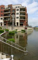
New 2011 Branson Flood Pictures and Website |

|
Sue Andersen Realty 417-334-8152 sueandersenrealty@gmail.com Please copy and paste address! |